40 Amazing Hikes Near Kanab That Prove Utah Is a Hiker’s Paradise
Just like how the desert goes on forever in Southern Utah and Northern Arizona horizons, the number of canyons, nature, and hiking trails in and near Kanab, Utah are limitless. Below are 40 of some of the best hikes in and near Kanab, along this beautiful stretch of the American expanse.
I have divided the best hikes in and near Kanab, Utah post, into three sections. They will be listed from closest to furthest out from Kanab:
- 2WD hikes in Kanab, Utah (within 10 miles)
- 2WD hikes near Kanab, Utah (Up to 90 miles)
- 4WD hikes in and around Kanab, Utah
Town of Kanab Utah
A trip past Kanab, Utah is likely if you plan on visiting iconic rock formations, slot canyons, or the Grand Canyon on your Southwest USA road trip. A surprisingly touristy town sitting along Highway 89, Kanab, Utah, offers visitors hip restaurants, trading post souvenir shops, and usual small-town America stuff to do.
But what is even more incredible is that Kanab is a hub for all the crazy amount of hikes surrounding it on all sides. The sandstone-rich landscape is filled with adventurous things to do, from short to all-day hikes, scenic drives to ATV accessible only viewpoints.
Basic Information of Hikes in and Near Kanab, Utah
Here are all the best hikes in and near Kanab, Utah, organized by distance from the Kanab Visitor center in the middle of town. Every hike will indicate basic statistics, like length in miles, difficulty, and elevation change. If elevation change is not stated, assume it will be minimal.
Most trails are dog-friendly and do not need a permit or additional fee, so assume you’re good unless I have specifically called out otherwise. Many of the hikes are also in remote areas of the desert, so don’t forget to pack your hiking essentials. Get ready to be psyched for 40 hikes in and near Kanab, Utah!
Bad Weather Warning: Look at the forecast for any bad weather. Any amount of rain can cause a flash flood in slot canyons.
Best Hikes in Kanab Utah (up to 10 miles)
1. K Hill Trail
1.7 miles from Kanab, Utah
- Off the Beaten Path: No
- Type of Trail: Out-And-Back
- Total Miles: 1.87 Miles
- Elevation Change: 200 Feet
- Difficulty: Easy
- Trailhead GPS: (37.046494, -112.514732)
From anywhere in downtown Kanab, spot a giant letter “K” on top of the nearby cliffs towering over the town’s everyday goings. If you haven’t guessed it yet, K Hill Trail directs you along a nice, easy stroll to the foothills of the iconic symbol of Kanab.
Expect beautiful views of the Vermilion Cliffs, Kanab, and the Kaibab Plateau at the top. You can continue onto Tom’s Canyon Trail, turning left from a T junction near the trailhead.
2. Tom’s Canyon loop
1.8 miles from Kanab, Utah
- Off the Beaten Path: No
- Type of Trail: Out-And-Back
- Total Miles: 3 Miles
- Difficulty: Easy
- Trailhead GPS: (37.05139,-112.51985)
Tom’s Canyon Trail is a pleasant, well-marked hike along the dry ravine floor that leads to a box canyon at the end. The first section of the hike meanders uninterestingly through new development before entering the more scenic canyon.
3. Squaw Trail
1.9 miles from Kanab, Utah
- Off the Beaten Path: No
- Type of Trail: Out-And-Back
- Total Miles: 3.2 Miles
- Elevation Change: 760 Feet
- Difficulty: Easy/Moderate
- Trailhead GPS: (37.058334, -112.526377)
In northern Kanab, Squaw Trail traverses up the red rock rim to gorgeous panoramic views of the town and its red cliff surroundings. You can even see across the border of Arizona from the top platform. Several switchbacks wind up the cliff, with some narrow areas of rock scramble.
Squaw is universally considered offensive, so some now call this trail “the trail with no name.”
Tip: If you only do one hike in Kanab, it should be Squaw Trail. This trail can also be combined with other popular Kanab hikes such as Tom’s Canyon and Cliffs Trail to turn it into a 7.7 mile loop.
4. Raven and Roadrunner Bike and Hike Loops (part of Squaw Hike)
1.9 miles from Kanab, Utah
- Off the Beaten Path: No
- Type of Trail: Loop
- Total Miles: 2.1 miles Singletrack (1.2 miles Raven/0.9 miles Roadrunner)
- Elevation Change: 760 Feet
- Difficulty: Moderate/Difficult for Biking
- Trailhead GPS: (37.059076, -112.527872)
For the bikers out there looking for some adventure in the heart of Kanab, check out Raven/Roadrunner, a trailhead just west of Squaw Trail. Raven, a short but challenging singletrack bike trail, signifies the first completed section of a planned mountain bike trail system. The loop is generally completed clockwise but can be ridden in either direction.
Raven terminates at the junction with Squaw Trail, where you can then continue onto the multi-use Roadrunner Trail.
Note: Although primarily used as a bike loop, you are free to hike Raven and Roadrunner as well.
5. Greenhalgh Hike (Green Kanab Trail)
3.8 miles from Kanab, Utah
- Off the Beaten Path: Yes
- Type of Trail: Out-and-Back
- Total Miles: 4 miles
- Elevation Change: 200 Feet
- Difficulty: Moderate
- Trailhead GPS: (37.0776,-112.54015)
Hike along the tops of the Vermilion Cliffs across Trail Canyon, a path once used to carry mail on horseback between Kanab across the Coral Pink Sad Dunes to neighboring small towns.
Fun fact: Outgoing mail would be lowered using a pulley system down the cliffs to an awaiting mailman to continue the historic paper route.
Half a mile in, the trail splits into Greenhalgh trailhead, climbing up the cliffs to get sandstone mountaintop views.
Directions: Park at ATV Bridge to walk the sandy 0.4 miles to the trailhead starting point. The trail is open to foot and horse only.
6. Bunting Trail
3.9 miles from Kanab, Utah
- Off the Beaten Path: Yes
- Type of Trail: Out-and-Back
- Total Miles: 4.2 miles
- Elevation Change: 1404 Feet
- Difficulty: Hard
- Trailhead GPS: (37.021420, -112.559630)
Just west of Kanab, Bunting Hike strenuously burns the thighs up a steep rocky trail to fantastic vantage points of Kanab, Vermillion Cliffs, and even the first step of Grand Staircase and Bryce Canyon National Park. Try spotting well-preserved Native American petroglyphs and dinosaur tracks on your way up.
7. Dinosaur Tracks
4.1 miles from Kanab, Utah
- Off the Beaten Path: No
- Type of Trail: Out-and-Back
- Total Miles: 0.7 miles
- Elevation Gain: 300 Feet
- Difficulty: Moderate
- Trailhead GPS: (37.084210, -112.539260)
Step back in time to the Jurassic period, when at least 20 species of dinosaurs roamed this area of the American Southwest. View the remnants of 185 million-year-old dinosaur tracks embedded into the rock, relics of a time long lost.
Although short, the Dinosaur Tracks hike in Kanab Utah is steep and requires a strenuous scramble to the top of an unmarked path. Kind souls before you have marked the dinosaur tracks with rock cairns to more easily find the prints.
Directions: Park at the Port of Entry, where all the trucks are. The trailhead starts at the port-o-potties.
8. Jackson Flat Reservoir
4.2 miles from Kanab, Utah
- Off the Beaten Path: No
- Type of Trail: Loop
- Total Miles: 3.5 miles
- Difficulty: Easy
- Trailhead GPS: (37.00721,-112.51635)
Change up the desert scenery by visiting the local watering hole, Jackson Flat Reservoir. An easy 3.5 mile paved path loops around the entirety of the reservoir, with opportunities for fishing, (non-motorized) boating, and watching wildlife.
Note: If you need a fishing license, you may purchase them from Glaziers Market. Check the visitor center if you are looking for paddleboard, canoe, or kayak rentals.
9. Mansard Trail
6.4 miles from Kanab, Utah
- Off the Beaten Path: No
- Type of Trail: Out-and-Back
- Total Miles: 5.3 miles
- Elevation Change: 1223 Feet
- Difficulty: Moderate
- Trailhead GPS: (37.03459,-112.42374)
Hike in Kanab amongst history, passing ancient Anasazi petroglyphs along this strenuous 5.4 mile hike ascending uneven terrain switchbacks and rock scramble before flattening at the top.
The summit features another overlook with views of Kanab, Vermilion Cliffs, and the Kaibab Plateau from the southwest side. A rock shelter preserves the rare occurrence of petroglyphs on the floor, so watch where you step.
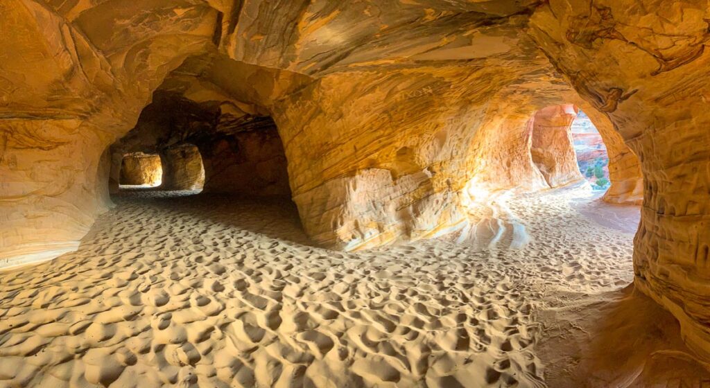
10. Moqui Sand Caves
6.4 miles from Kanab, Utah
- Off the Beaten Path: No
- Type of Trail: Out-and-Back
- Total Miles: 1 mile
- Elevation Change: 124 Feet
- Difficulty: Moderate
- Trailhead GPS: (37.113752, -112.554459)
Look out from beneath the domed arches of Moqui Sand Caves. These manmade caves are actually the remains of the glass mining industry extracting minerals from the sand. This impressive hillside cave system is one of the best hikes in Utah.
Find the easiest entry point up a sandy scramble starting from the Kanab Sand Caves vehicle turn-out. Although steep, people of all ages are welcome on this short hike. Empty your shoes and shake the sand out of your hair after!
Just 1 mile north of the parking lot, Moqui Museum depicts the history and life of Southern Utah, displaying Native American Artifacts, dinosaur tracks, and various minerals.
11. Best Friends Animal Sanctuary
7.8 miles from Kanab, Utah
Welcome Center Address: 5001 Angel Canyon Rd, Kanab, UT 84741
The beloved Best Friends Animal Sanctuary welcomes 1,700 cats, dogs, horses, birds, pigs, and rabbits to provide them a second chance at life. With public tours running all day, warm your heart by bringing the whole family to engage and learn about different species of animals living under their care.
Explore the nearby areas of the sanctuary at your own pace, discovering a rock amphitheater at Angel’s Landing, movie set remains of Disney Barn, and Native Anasazi ruins at Indian Ruins. Nearby Angels Overlook is the final resting place for many pets, but at least they have breathtaking views.
12. Kanab Creek
9.3 miles from Kanab, Utah
- Off the Beaten Path: No
- Type of Trail: Creek Access
- Total Miles: Short Distance
- Trailhead GPS: (37.145014, -112.540335)
Just before Turtle Rock, a little further north of Best Friends Animal Sanctuary, follow the dirt road to a nifty little slot canyon with a small stream. The ever-flowing Kanab Creek rushes along the canyon wall, eventually feeding into the Grand Canyon. The water level flows between ankle deep to waist high on this hike down to see the dam.
13. Hidden Lake Recreation Area from Kanab Creek
10.2 miles from Kanab, Utah
- Type of Trail: Out-and-Back
- Total Miles: 1.5 miles from Kanab Creek
- Difficulty: Easy, but extremely sandy
- Ending GPS Location: (37.138930, -112.533500)
Explore Hidden Lake 1.5 miles away from Kanab Creek to discover an underground lake inside a sandstone cliff opening to form a cave. This cave used to act as a refrigerator of sorts for settlers to keep food and dairy fresh.
Best Hikes Near Kanab, Utah (up to 90 Miles)
14. Belly of the Dragon
18 miles from Kanab, Utah
- Off the Beaten Path: No
- Type of Trail: Out-and-Back
- Total Miles: 0.5 mile roundtrip tunnel, can continue 4 miles up the wash
- Difficulty: Very Easy
- Trailhead GPS: (37.21169,-112.68505)
The Belly of the Dragon hike is a short 0.5 miles round trip through a manmade highlight, a carved sandstone tunnel. Originally built as a drainage tunnel to direct water into the North Fork River, over time, the water flow carved ripples in the inner walls that mimic the insides of a mystical beast.
Park at the mouth of the tunnel. While exploring the pipe, note that there are a few rock scrambles to get through. If you want to prolong the hike, you can continue up the wash for 4 miles, ending in another small slot canyon.

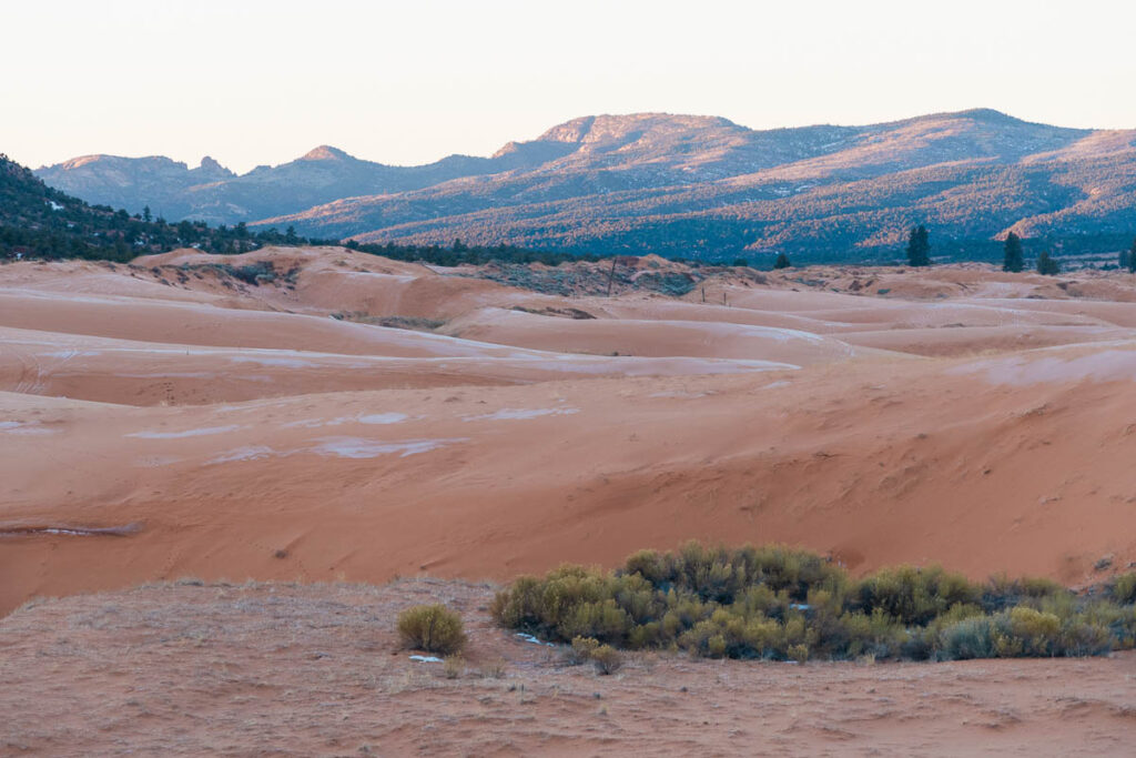
15. Coral Pink Sand Dunes State Park
21.6 miles from Kanab, Utah
- Off the Beaten Path: No
- Permit Required: $8/vehicle
- Address: 2500 S Sand Dunes Rd, Kanab, UT 84741
Coral Pink Sand Dunes State Park is one of the most popular things to do near Kanab, Utah. To see why the park got its name, head there before sunrise or sunset just as the light hits the sand at just the right angle to see the soft shades of pink. At the height of the day, the sand turns a more familiar orangey hue.
Coral Pink Sand Dunes offers sandboarding, 1200 acres of ATV’ing, and hiking. Sandboard rentals and ATV tours are available from the visitor staging area. There are two off-the-beaten-path 4WD hikes nearby: South Fork Indian Canyon Pictographs and Hell Dive Pictographs.
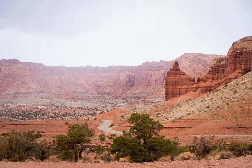
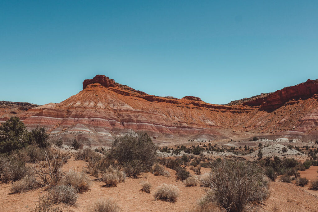
16. Paria Townsite and River Valley Trail
37.2 miles from Kanab, Utah
- Off the Beaten Path: No
- Type of Trail: Out-and-Back
- Total Miles: 22 miles one-way, turn back when ready
- Elevation Change: 760 Feet
- Difficulty: Easy to Paria Ghost Town, Moderate Up River
- Parking GPS: (37.236807, -111.957554)
The downfall of the town of Paria began in the 1860s during the Blackhawk War. Since that first misfortune, flooding, overgrazing, and poor dam construction slowly forced people to abandon their homes for greener pastures.
In an area of extreme beauty, a few western films have been shot here. But, in 2006, the film set had also been burned down. Today, a few foundations and remnants of a past time are left behind among the rainbow cliffs.
Before hitting Cottonwood Canyon Road, turn in at mile marker 31 and drive 5.6 miles to the parking area near Paria Townsite and cemetery. Follow north along the river to continue an adventurous hike through the valley. Roads can get extremely muddy.
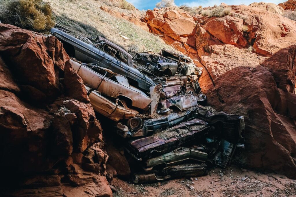
Catsair Canyon Trail
39 miles from Kanab, Utah
Halfway between Kanab and Page sits one of southern Utah’s most accessible slot canyons, Catsair Canyon.
Catsair Canyon Trail entails two separate hikes – Riprap and Writings. On the map, these two hikes seem to align perfectly, but they are indeed two separate canyons with their own respective parking lots. A large dropoff/cliff between the two trails can leave you stranded if attempted. Don’t go down places you can’t get back up.
17. Catsair Canyon RipRap
- Off the Beaten Path: No
- Type of Trail: Out-and-Back
- Total Miles: 1 mile roundtrip
- Difficulty: Easy
- Trailhead GPS: (37.12647,-111.95482)
Head down the wash of Catsair Canyon RipRap about a quarter-mile to view the Detroit Riprap, a pile of junk cars piled together in the middle of nowhere. Why are they there? They do serve a purpose! The pile of crushed vehicles keeps the sandy hillside from eroding during storms.
18. Catsair Canyon Writing
- Off the Beaten Path: No
- Type of Trail: Out-and-Back
- Total Miles: 1.5 mile roundtrip
- Difficulty: Easy
- Trailhead GPS: (37.12647,-111.95482)
Continue east on Highway 89 between mile markers 24-25; you will reach the separate parking lot for Catsair Canyon Writing. To reach the trailhead, drive a short distance after entering through the closed gate (close it behind you)
Hike through the narrow canyon to see ancient and “modern” petroglyphs on the inner walls. Continue to the end of the box canyon for some spectacular views of the area.
Zion National Park
42.8 miles from Kanab, Utah
No list of hikes near Kanab Utah would be complete without mentioning Zion National Park. Although Zion is home to plenty of hikes and treks, the two most popular hikes are some of the most unique in the United States: Angel’s Landing and the Narrows.
Recommendation for both hikes:
- Get an early start, and don’t start later than late morning unless you are a fast hiker. Both hikes are within the Zion shuttle area, which terminates at 7:15pm.
- During shuttle season, visitors can’t drive their personal car into Zion Canyon Scenic Drive. Park at Zion Lodge to get onto the park shuttle.
- Hiking the Narrows and Angel’s Landing are both strenuous hikes but not technically challenging nor dangerous hikes. (Angel’s Landing hike does get narrow at the end, just don’t look down)
- Leave time to drive the rest of the scenic route!
- If you plan on visiting more than two national parks this year, save money by buying a National Park Pass.
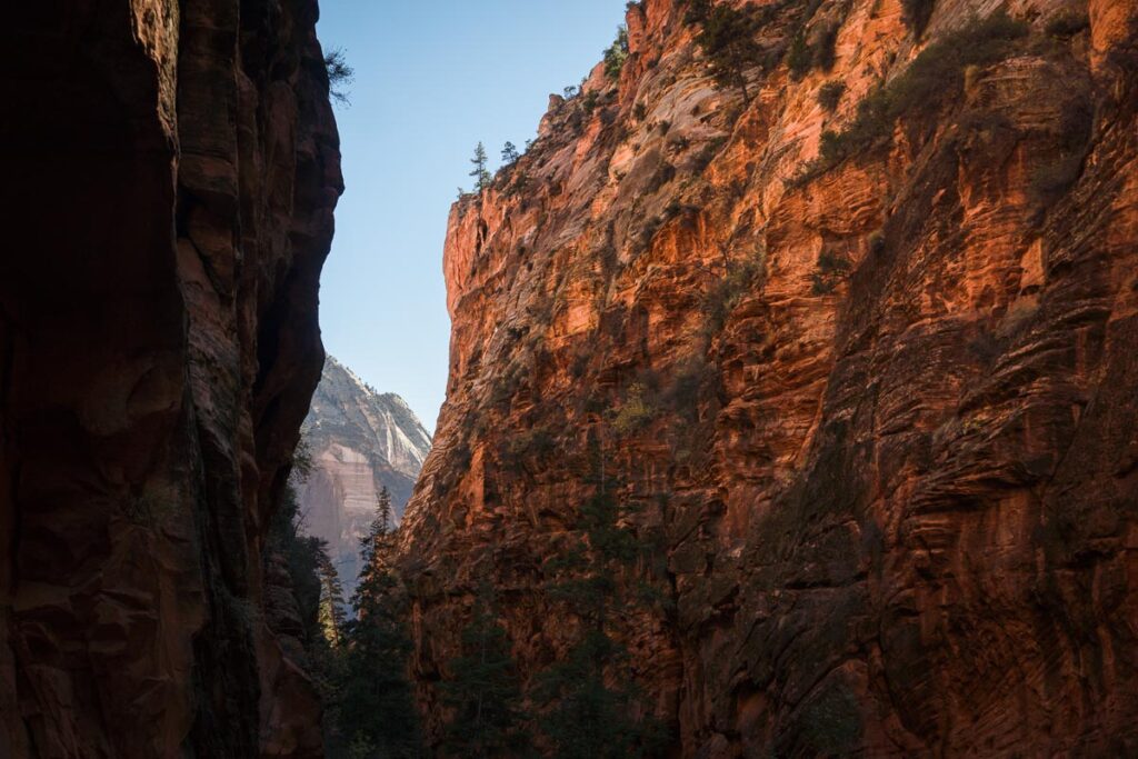
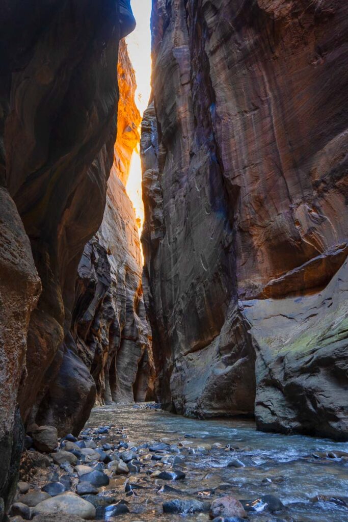
19. The Narrows Hike
- Off the Beaten Path: No
- Type of Trail: Out-and-Back
- Total Miles: One Way 2.5 miles to Orderville Canyo & Wall Street, 2 more miles to Big Springs
- Elevation Gain: Basically Flat
- Difficulty: Moderate
- GPS Trailhead: (37.285336, -112.947176)
Wade through the shin to waist-level icy waters of the Virgin River while winding through Zion’s The Narrows hike. Towering cliffs envelop you on both sides as you wade upstream through this beautiful slot canyon.
With no set ending point, feel free to turn back whenever you are ready. Take the shuttle to the final stop, Temple of Sinawava, to start the hike at Riverside Walk, the gateway to The Narrows. In the winter, icy waters require you to rent dry suit clothing to prevent hypothermia.
Note: Due to high water levels from snowmelt, The Narrows is typically closed between mid-march to late May.
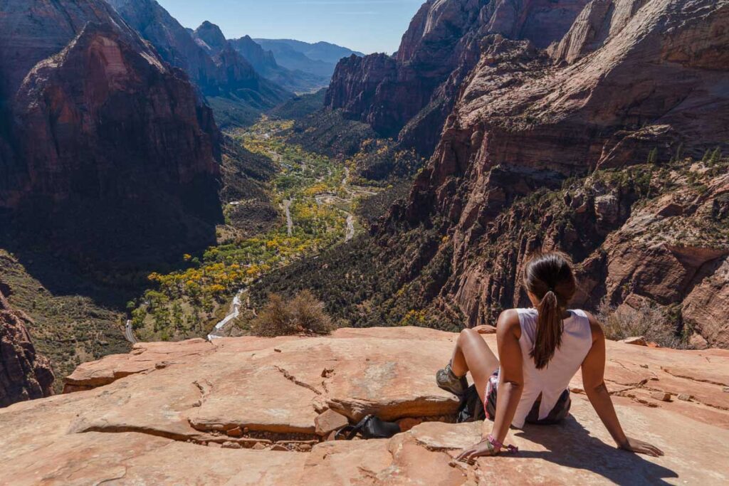
20. Angel’s Landing Hike
- Off the Beaten Path: No
- Type of Trail: Out-and-Back
- Total Miles: 4.4 miles
- Elevation Gain: 1,600 Feet
- Difficulty: Hard
- Permit: Yes, $6/application up to 6 people for the day-before
- GPS Trailhead: (37.25909,-112.95122)
Summit Angel’s Landing, the 5,790 feet giant rock tower to be awarded the best views in all of Zion. The last section of the hike may not be best for those scared of heights, with little railing protection and narrow footpaths.
Honest Opinion: Angel’s Landing may be one of the best hikes in America.
Take the shuttle to the Grottos, and begin your adventure at Grotto trailhead, crossing a bridge across the Virgin River.
Tip: Starting 2022, Day-before lottery permits are required for the trail from Scout Lookout to Angel’s Landing.
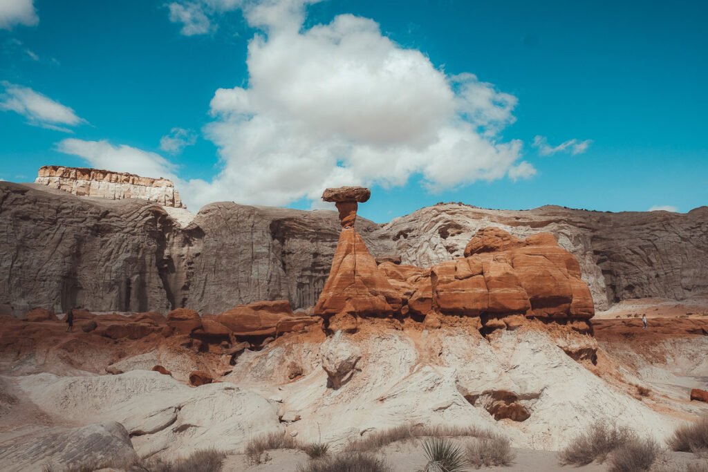
21. Toadstool Hoodoos
44 miles from Kanab, Utah
- Off the Beaten Path: No
- Type of Trail: Out-and-Back
- Total Miles: 2 miles roundtrip
- Difficulty: Easy
- Trailhead GPS: (37.101310, -111.873310)
Enter the Toadstool Hoodoos to a world of strange balancing rock formations in the Grand Staircase-Escalante National Monument. The mushroom head of hoodoos forms when the softer sediment erodes beneath the firmer rock, leaving odd balancing shapes and different colors throughout this straightforward, mostly flat hike.
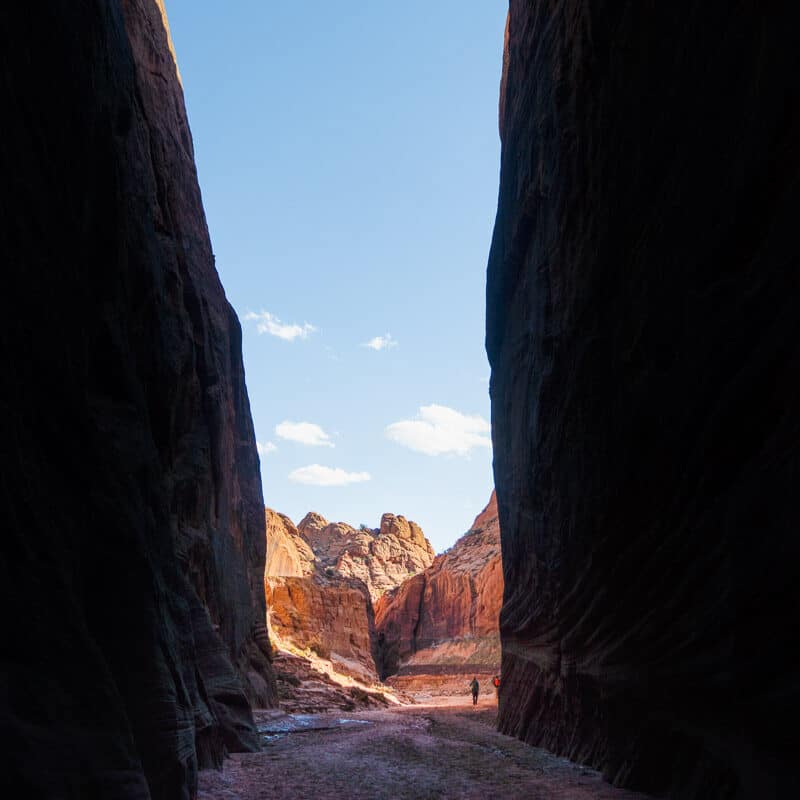
22. Buckskin Gulch Slot Canyon
46 miles from Kanab, Utah
- Off the Beaten Path: Yes
- Type of Trail: Out-and-Back
- Total Miles: 21 miles one way
- Elevation Change: 500-1500 Feet
- Permit: Yes, $6/person Dayuse, $5/person Overnight – booked in advance)
- Difficulty: Moderate – Hard due to Length
East of Kanab in the depths of the Vermilion Cliffs Wilderness, explore Buckskin Gulch, the longest and deepest slot canyon in the southwest United States (and possibly the world). Neighbors with the famous Wave hike, Buckskin Gulch runs 16 miles through valleys and peaks of sandstone walls.
Drive down the dirt House Rock Valley Road to reach Buckskin Gulch. Despite being in BLM (Bureau of Land Management) area, permits are required. Due to its remote location, there is no cell service in this entire area.
There are a few methods of exploring Buckskin Gulch: Buckskin Trailhead, Middle Trailhead, or cutting in through Wire Pass.
Note: If you plan on hiking the entire length of the canyon, most people plan an overnight backpacking trip. Water from recent rains can linger for months or carry obstacles that may obstruct your path to continue.
23. Buckskin Gulch via Wire Pass
- Off the Beaten Path: No
- Type of Trail: Out-and-Back
- Total Miles: 5.6 Miles
- Elevation Change: 600 Feet
- Permit: Yes, $6/person Dayuse
- Difficulty: Easy
- Wire Pass Trailhead GPS: (37.01916,-112.02529)
Wire Pass allows you to cut right into the best part of Buckskin Gulch. After 1.5 miles of the boring Wash Trail, a towering narrows sucks you into the depths of the canyon, which open up into a beautiful confluence. You can turn either right or left from the intersection as both have equally impressive bits. This is a bucket list hike near Kanab Utah for those road tripping through this area.
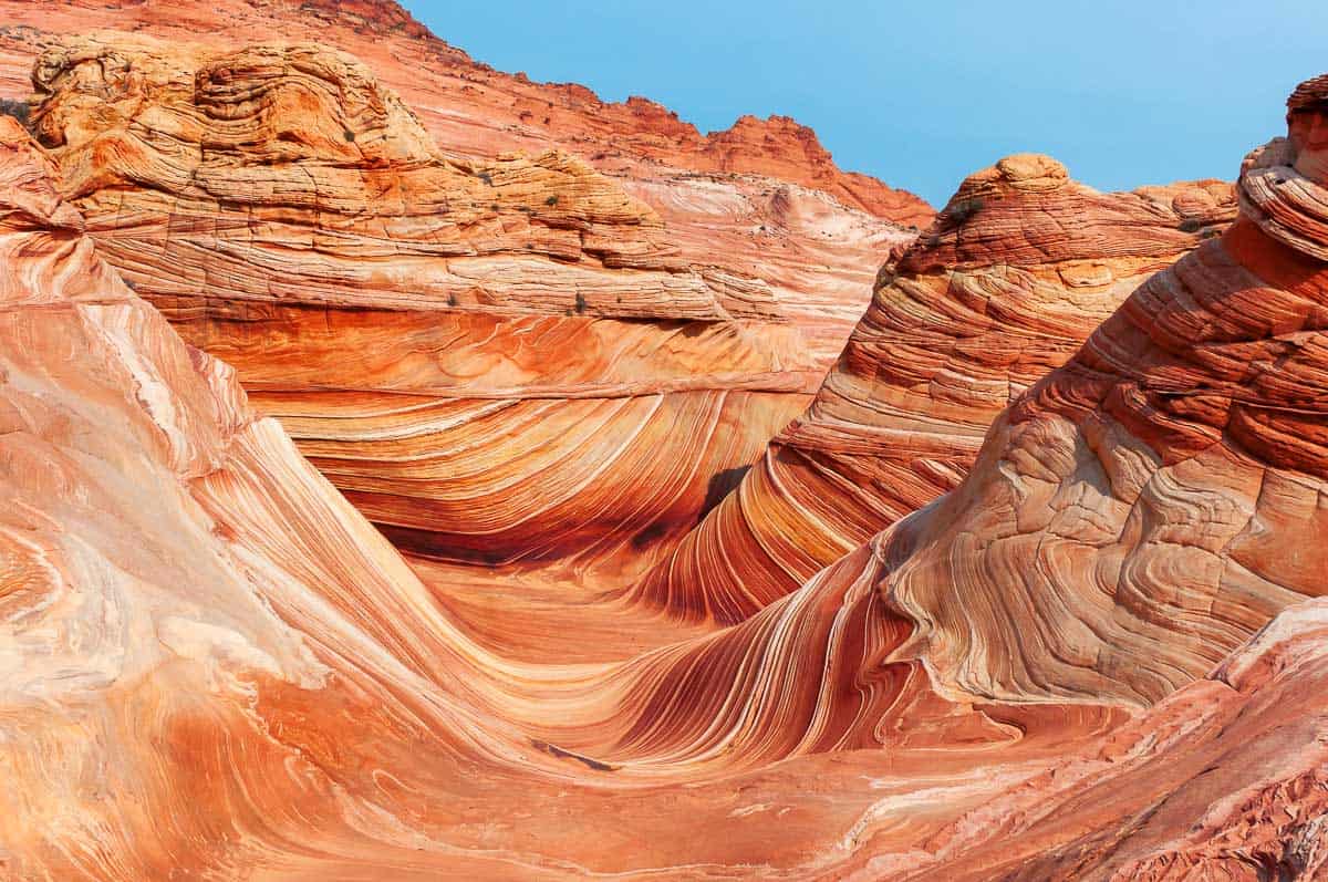
24. The Wave Trail
46 miles from Kanab, Utah
- Off the Beaten Path: Yes, due to Permit Restrictions
- Type of Trail: Out-and-Back
- Total Miles: 6.7 Miles
- Elevation Change: 1,230 Feet
- Difficulty: Moderate (No shade & can have high winds)
- Permit: Yes, $9 difficult to obtain ($100,000 max fine/jail time if caught without)
- Trailhead GPS: (37.01916,-112.02529) – Same trailhead as Wire Pass
A smooth patterned ripple lays before you, stuck in time. What you’re looking at is not water, but the famous Southwest rock formation, The Wave. So popular and fragile is the landscape, The Wave limits daily visitors to 64 individual people or 16 groups per day max!
Tip: Don’t just stop at The Wave. Make sure you continue to see the arch and the mini cave dune.
How To Enter The Wave Lottery
“The Wave” Advanced Permit Lottery
Coyote Buttes North Advanced Permits are notoriously difficult to obtain as demand far outnumbers supply. Lottery drawings open up four months in advance of your trip date. The online lottery fee is $9 per group held on recreation.gov.
“The Wave” Daily Permit Lottery
Starting from 2022, lotteries are no longer organized for free at the Kanab Center Gymnasium. All lottery permits have moved online, including the daily permits.
Send in a $9 application two mornings before your desired hiking day. You must be within the geofenced area of Southern Utah/Northern Arizona to apply. Check here for the latest permit instructions.
25. Aspen Mirror
52.1 miles from Kanab, Utah
- Off the Beaten Path: No
- Total Miles: Easy Stroll
- Elevation: 8500 feet
- Turn-In GPS Location: (37.517, -112.682)
Get away from the heat in the summer months at Aspen Mirror Lake, a beautiful crystal-clear lake surrounded by green pines and filled with rainbow trout. There is plenty of wildlife to be on the lookout for, fish to reel in, and trails for hiking, biking & OHVs.
Nearby Navajo Lake is another beauty to explore, offering a campground on site.
26. Cascade Falls
57 miles from Kanab, Utah
- Off the Beaten Path: No
- Type of Trail: Out-and-Back
- Total Miles: 1.2 miles
- Elevation Gain: 137 Feet
- Difficulty: Moderate
- Trailhead GPS: (37.49728,-112.75162)
If you’re planning a visit to nearby Cedar Mountain or Aspen Mirror Lake, detour to the short 1 mile waterfall hike to Cascade Falls. This out-and-back route hugs the mountainside along steep dropoffs to a waterfall flowing out of the cliff rocks at the end of the trail.
Tip: The best time to visit Cascade Falls is between June to October. Water levels can be low enough that the waterfall dissipates. Winter brings road closures and inaccessible icy conditions on the trail.
27. Wahweap Hoodoos
58.5 miles from Kanab, Utah
- Off the Beaten Path: Yes
- Type of Trail: Out-and-Back
- Total Miles: 10 miles roundtrip
- Elevation Change: 435 Feet
- Difficulty: Moderate
- Trailhead GPS: (37.102160, -111.676590)
Another excellent option to see the unique balancing rock formations is navigating through Wahweap Hoodoos and exploring its hidden little slot canyons. Local legends believe that the hoodoos were remnants of people turned to stone.
Directions: 2WDs can drive past the softball field and two fish hatcheries before parking just before the corral and creek. 4WDs have the option to continue past the stream another 0.3 miles, where the Wahweap Hoodoos trailhead begins.
28. (Lower) Hackberry Canyon
60 miles from Kanab, Utah
- Off the Beaten Path: Yes
- Type of Trail: Out-and-Back Maintained Dirt Road
- Total Miles: 4.5 – 12 miles roundtrip
- Elevation Change: Minimal – 1,932 Feet
- Difficulty: Easy – Hard, depending on how far you go
- Trailhead GPS: (37.25698,-111.90873)
You already know this part of the American Southwest is filled with slot canyons. Off Cottonwood Canyon Road, add the little-known narrow slot canyon Hackberry Canyon to your list too.
Begin in the easy wash of Lower Hackberry Canyon. Keep cool along the trail as an ankle-deep shallow stream flows beside you, leading to dinosaur tracks (2.1 miles in), then Watson’s cabin (5.2 miles in.) Lower Hackberry Canyon leads into Hackberry Canyon to another scenic sight, Sam Pollock Arch.
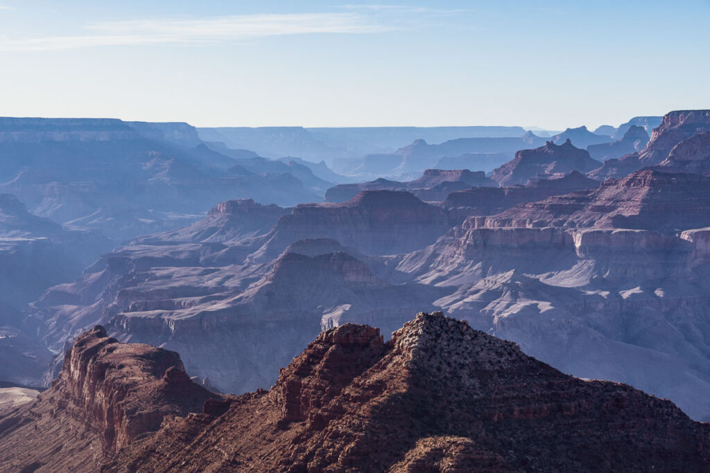
29. North Rim of The Grand Canyon
81.1 miles from Kanab, Utah
Only making up 10% of annual Grand Canyon visits, the North Rim of the Grand Canyon is worthwhile for those wishing to explore this Northern Arizona crown jewel without the crowds.
For those coming in from Kanab, Utah, the north rim is only an 81 mile drive versus 200+ miles to the South Rim visitor center. Plan your visit to the North Rim on recreation.gov.
30. Snow Canyon State Park
90.4 miles from Kanab, Utah
- Address: 1002 Snow Canyon Dr, Ivins, UT 84738
Cheating since I am mentioning an entire park rather than a trail, but if Zion wasn’t right next to Snow Canyon State Park, it might have been a national park.
Just outside St. George, Snow Canyon rivals the beauty of its neighbor Zion National Park, but without its crowds. Explore the lava tubes, petrified sandstones, and panoramic desert views. All the must-do hikes are moderately short, so you can see much of the park in one long day.
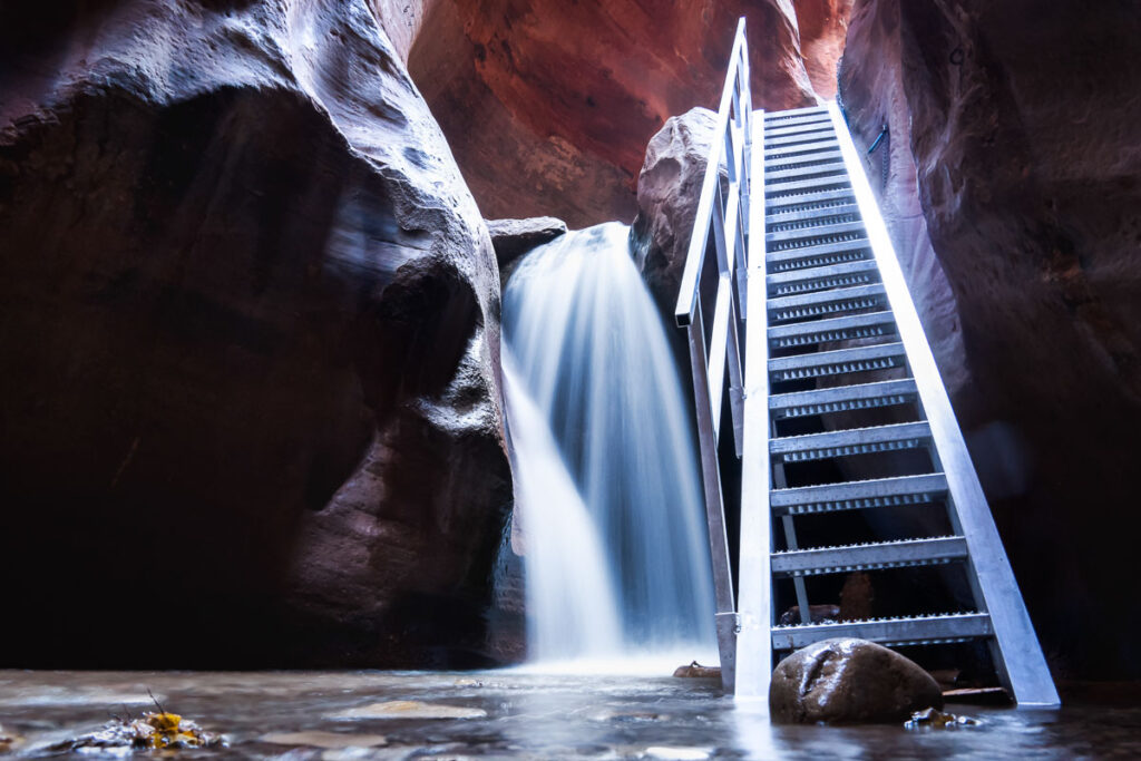
31. Kanarra Creek Canyon Waterfall Hike
90.5 miles from Kanab, Utah
- Off the Beaten Path: No
- Type of Trail: Out-and-Back
- Total Miles: 3.7 miles
- Elevation Gain: 650 Feet
- Difficulty: Moderate
- Dog-Friendly: No
- Permit: Yes, $12/person, limited to 150 permits/day (online/in-person)
- Trailhead GPS: (37.53715,-113.17535)
Kanarra Creek Canyon Waterfall hike is like a smaller version of The Narrows in Zion National Park. Trudge through the unavoidable ankle to shin-deep icy water before reaching the best part of the hike, the waterfall. Climb the ladder to continue up the slot canyon, but the further you go, the deeper the water.
4×4 in and Near Kanab
Unfortunately, many hikes near Kanab, Utah, and this part of the American Southwest is on pure sand. 4WDs would be best to safely arrive at many trailheads, especially after precipitation. Due to this barrier of entry, assume that nearly every trail is Off the Beaten Path.
Tip: You can opt to hike many of the 4WD required roads adding to the total trail length. At times, it may even be advised to forgo a 4×4 and go all out for an ATV. A few ATV tour companies and outfitters are available for rent for the more popular hikes.
32. White Wave (White Tower)
12.8 miles from Kanab, Utah | White Tower GPS Location: (37.216172, -112.551449)
Who said that “The Wave” was the only one in the area? If you weren’t lucky enough to get a permit to the famous Wave, bypass the permit requirement to see the White Wave. Make a day of it by combining 4WD Peek a Boo Slot Canyon and the 2WD Sand Caves.
ATV Tours are available for White Wave, Great Chamber, and Peek-A-Boo Slot Canyon.
Directions:
- Turn right at the Peek a Boo parking area, heading northeast on Road 102.
- Cross the wash onto Road 107H, then turn left to 102H for 2.6 miles.
- Park here for a wash hike to the White Wave.
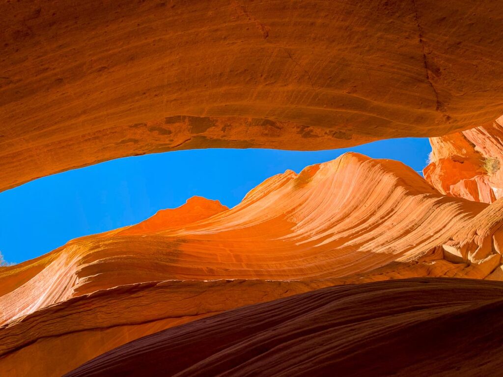
33. Peek-A-Boo Slot Canyon (Red Canyon)
12.8 miles from Kanab, Utah | Slot Canyon GPS Location: (37.178930, -112.557781)
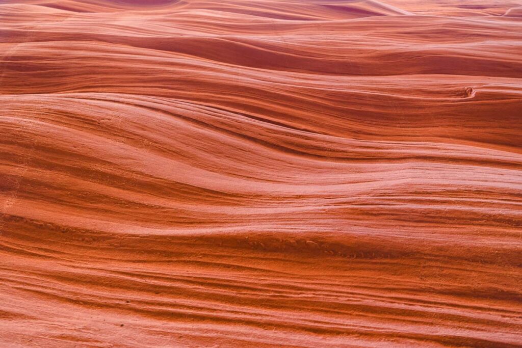
Peekaboo Canyon Kanab is one of the most legendary slot canyon hikes in the Kanab area. Wind your way through a breathtaking hike through fierce colored sandstone walls over 100 feet high. Some people even refer to Peek-A-Boo as Antelope Canyon without the crowds. This canyon has two sections, so make sure you reach the end.
Directions: Deep sand terrain makes arriving at the trailhead tricky. Stay on Road 102; do not turn left into very deep sand on Road 102L.
34. Huntress Slot Canyon
15 miles from Kanab, Utah | Trailhead GPS: (37.19051,-112.64567)
A charming canyon through colorful cliffs, Huntress Slot Canyon features pockets of water pools and toadstool rocks. Hike to the top of the hike’s famous landmark, Diana’s throne, to see views of Zion.
35. Sand Dune Arch
9.7 miles from Kanab, Utah | Arch GPS Location: (37.145669, -112.584522)
On your way to the Hell Dive Pictographs, detour at Sand Dune Arch, a unique arch jutting out of the otherwise flat ground. Just off Highway 89, the Sand Dune Arch is easily hikeable without a 4WD.
36. Hell Dive Pictographs
23 miles from Kanab, Utah | Hell Dive Approx Trailhead GPS Location: (37.044303, -112.640092)
Get ready for a sandy adventure into the depths of Pink Coral Sand Dunes to find Hell Dive Canyon. The pictographs are drawn in a cave, which locals believe Natives used to use for medicinal ceremonies or childbirth.
Directions: Turn west onto Hancock Road down Road 50. Continue on Road 51 (not Road 52 – extreme rock climbing).
37. Mail Drop
40 miles from Kanab, Utah | MailDrop Area GPS Location: (37.134935, -112.920825)
Near Coral Pink Sand Dunes State Park, enter at the confluence of Shunes Hollow Road and Whitney Road, running past Elephant Butte and Sand Butte. Wind through 25 miles of brush and juniper trees for sights of Zion National Park before hiking 1 mile up a sandy wash to the Maildrop lookout.
Mailmen historically made the dangerous hike to deliver mail before creating a pulley system to lower their packages down 300 feet cliffs instead.
38. Warriors Walk
41 miles from Kanab, Utah | Warrior’s Walk GPS Location: (37.094806, -112.896458)
Follow the same path as Maildrop Trail until you pass Elephant Butte. Turn left on Road 17 for 2 miles, then stay right for road 19 to 19A. This rough 5 mile section is only accessible by small 4x4s and ATVs to be awarded views of sandstone Slickrock with Zion peering behind.
39. Eagle Sink
42 miles from Kanab, Utah | Parking GPS Location: (37.05228, -112.154649)
A sinkhole that can even be viewed from the highway, Eagle Sink depresses 160 feet into the Earth. Admire how strange this planet is as you step up to the railings or hike along the edges, watching as birds soar in and out of the hole.
40. White Pocket
75.7 miles from Kanab, Utah | Parking GPS Location: (36.954861, -111.895415)
Another fantastic alternative to The Wave in the same area, White Pocket showcases a natural masterpiece of swirling grey, white, and orange sandstone formations. 10 miles of rugged off-road is rewarded with a much larger area to explore, no crowds, and no dealing with permit lotteries.
FAQ For Hikes In and Near Kanab Utah
Is Kanab Utah worth visiting?
100% yes. Nearby Moab certainly gets a lot more attention for its nearby outdoor activities, but Kanab has its own set of endless hiking trails and nearby iconic parks like Zion and The Grand Canyon.
What is the best time of year to visit Kanab Utah?
Not just for Kanab Utah, the best time to visit Southwest USA is shoulder seasons, spring and fall, to avoid the blazing heat of the summer and unexpected weather of the winter.
Related Post: Find the best way to plan your trip through the southwest USA.
What do I need to hike in Kanab?
Kanab Utah can be hot, hot, hot for most of the year. Bring plenty of water and basics like sunscreen and a hat, for most hikes are under the open sun with no shade. Even slot canyon hikes typically require hikes through an open wash before arriving into a shaded canyon.
Do you need a permit to hike in Kanab Utah?
Most hikes in Kanab Utah do not require a permit. A few notable hikes that require a fee are: The Wave, Buckskin Gulch, Coral Pink Sand Dunes State Park, Angel’s Landing, and Kanarra Creek Canyon. All National Parks in the area require an entry fee, so I recommend buying a National Park Pass.
What is there to see between Kanab and Page?
Check out my other post for everything to see between Las Vegas and Page, Arizona, on a road trip or pick from one of the many tour options between Las Vegas and Antelope Canyon. Many of the adventures are similar to this guide but organized in a road trip itinerary.
If you’re heading into Page, look for more outdoor adventures like Lake Powell, Horseshoe Bend, and more slot canyons in this city guide.
Bucket List Worthy? Hikes in and Near Kanab Utah
Kanab is filled with unlimited outdoor recreational opportunities. This list of 40 hikes in and near Kanab, Utah, only calls attention to most of the best hikes in the area but is far from conclusive. An infinite amount of exploration is around every sandstone cliff in this area of Southwest USA.
If you can’t decide which hikes in and near Kanab, Utah to pick, here are some of the best to add to your Kanab bucket list:
- Moqui Sand Caves
- Zion National Park
- Peek-A-Boo Slot Canyon
- Buckskin Gulch
- The Wave
Catherine Xu is the founder and author of Nomadicated, an adventure travel blog that helps travelers cross off their bucket list. Since discovering traveling in 2015, she has lived and journeyed to 65 countries across 5 continents and vanlifed the west coast USA for 2+ years. These days, she splits her time in Southeast Asia and California while sharing her travel stories and resources based on first-hand experiences. Catherine's other works has been referenced in major publications like MSN, Self, and TripSavvy.